
| Go to Home Page
|
Help |
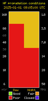
To use the Ionospheric Map below:
1) Select the 'Map centre at longitude:' to 0° then,
2) Refer to frequency and associated colour to the right hand side of the map. Multiply the frequency by a 'X' factor of '4', this gives you the Maximum Useable Frequency (MUF) for the associated colour on the map. Note: The frequencies given on the right are calculated from a none Tangential propagation, i.e. strait up and down and that's why we require the 'X' factor. |